Ottawa Council and the NCC tell residents: “say goodbye to Ottawa Greenspace”
Some very important decisions on the future fate of public greenspace is happening right now (December 2025). Decisions and deals are being made by Ottawa Council and staff (“the city”) and the National Capital Commission (“NCC”) without ANY consultation nor transparency.
These changes are being made under the guise of the Zoning By-law review but the magnitude of the changes being proposed requires significantly more scrutiny, public engagement and transparency.
It is especially problematic as these changes were NOT implemented in the First draft of the zoning by-law. Residents are completely unaware that such dramatic changes occurred AFTER Draft 1. You can find more information at Greenspace Alliance.
TLDR: The Hunt Club Community Association (HCCA) created this excellent summary
There are multiple areas of concern including:
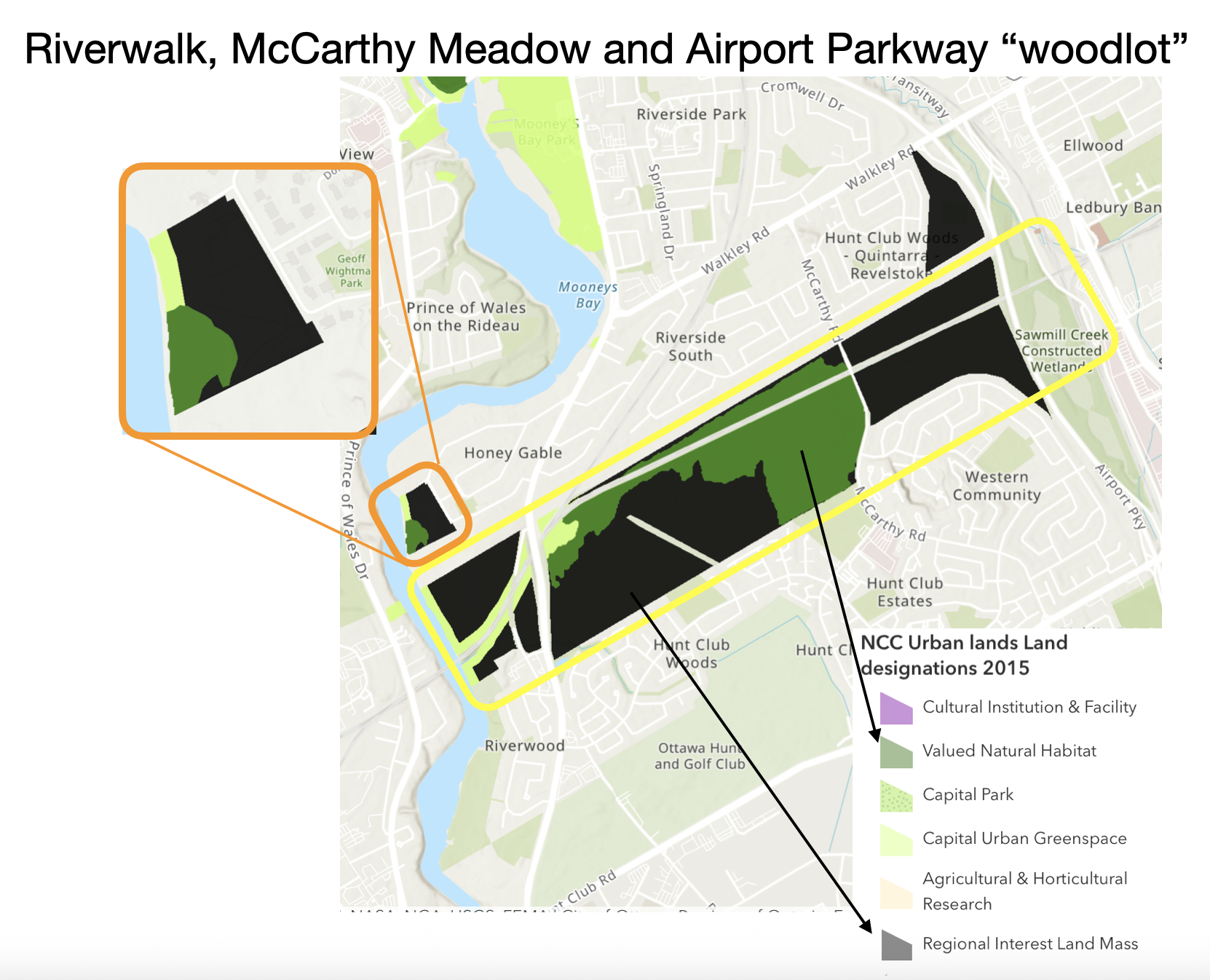
A. “Riverwalk” between Revelstoke Drive & Rivergate Way (Riley Brockington, MPs David McGuinty & Yasir Naqi)
B.. “McCarthy Meadow” surrounding McCarthy Woods. (Riley Brockington, MP David McGuinty)
C. “Airport Parkway ‘Woodlot’”* north of Plante Drive. (Riley Brockington, MP David McGuinty)
D. Woodroffe-Merivale section of the Southern Corridor (Laine Johnson, MP Anita Vandenbeld)
E. Coronation Woods on Station Blvd in Alta Vista (Marty Carr, MP David McGuinty)
*Note: OSEAN would prefer the use of forest to better represent the ecological value and gifts that are provided by trees, rather than the human-centric term “woodlot”, but for consistent with city terminology, we use the word “woodlot”
Ready to take action now?
Use our Councillor template to call/email your councillor.
Use our MP Template to call/email your MP AND the NCC to request the NCC withdraw their zoning requests.
RSVP to join us on Saturday December 13th for a walk through these woods - Family Friendly (9:30-11:30) and Adult Greenspace Stewardship (11-12) Options!
Want more information - Keep Reading….
Resources that have been developed to communicate and advocate for better protection of this land mass (and a return to the 1st Draft) as well as relevant documents:
A. Greenspace Alliance Submission to the city
B. Hunt Club Community Association Feedback on Draft 3 of the new Zoning By-law
C. 1 page summary shared with MPs David McGuinty and Yasir Naqvi
D. Detailed briefing shared with MPs David McGuinty and Yasir Naqvi
E. Hunt Club Community Association Request to Carol Ruddy (City Urban Planner) to reconsider the Draft 3 changes.
F. Greenspace Alliance appeal with the Ontario Land Tribunal (January 2023)
G. Greenspace Alliance appeal of the Ottawa Official Plan (May 2007)
Summary of the issue
The Hunt Club Community Association (HCCA) created this excellent summary of why these changes are problematic and why the city should adopt the zoning from Draft 1.
The City’s own environmental study in 2005 identified large portions of this corridor (“urban natural areas”) have moderate to high ecological value. (Details on the these areas can be found here)
This region also provides significant benefit to all Ottawa residents due to the high concentration of trees AND the large expanse of open natural space that is used daily for recreation, exercise and mental health.
What is the importance of this high concentration of trees?
- This area significantly contributes to Ottawa’s Tree Canopy goal of 40%. (The River Ward cannot afford to lose these trees as the ward is only at 25% Tree Canopy)
B. These trees contribute significantly to local cooling and rain water management (remember all that flooding a few years ago.. it would have been MUCH worse without these trees and wetlands).
C. This greenspace contributes to improved air quality by absorbing air pollution.
NCC’s role in Rezoning as the owner of the all the property in the Southern Corridor
The lands in question for the southern corridor are owned by the federal government and managed through the NCC. Rezoning of this land cannot be done by the city WITHOUT the agreement of the NCC. Why would the NCC choose to rezone this land?
In January 2025, the NCC revised their Capital Urban Lands Plan. A Plan meant to “provide detailed direction and guidance for the use and stewardship of federal lands for which the NCC has jurisdiction pursuant to the National Capital Act.” All the NCC land up for rezoning East of the Rideau River is currently designed as “Regional Interest Land Mass Overlay”. “Properties supporting regionally-significant recreational, ecological or infrastructure-support functions have been identified as part of the Regional Interest Land Mass (RILM) Overlay. [This] designation is to safeguard the public use of the RILM lands over the long-term and to conserve the public interest functions they support.” This does NOT align with a “Development Reserve” Zoning from the city. Read more about NCC here.
Woodroffe-Merivale
- Development Reserve Zoning by city pre-empts Public Consultation
The NCC’s own Capital Urban Lands Plan (2025) the NCC has described the Woodroffe-Merivale corridor as “Non-Designated NCC Property” and has placed this land in the Canada Public Land Bank for sale or lease. The proposed Development Reserve zoning, however, will pre-empt the results of the City’s public consultations on the Merivale Secondary Plan.

Southern Corridor Chronology:
The NCC purchased the Hunt Club portion of the Southern Corridor in 1953 for a ring road and then declared this land to be “surplus” in 1988. Its original plan, shared with the former City of Ottawa in 1997, was to develop residential subdivisions in the McCarthy Meadow and the Airport Parkway woodlot. The Greenspace Alliance was formed to oppose this plan - along with other portions of the Southern Corridor - and secured a number of changes in the new City’s 2003 Official Plan.
As a result, the 2003 Official Plan designated most of the Hunt Club corridor as Major Open Space, while leaving a large portion of the McCarthy Meadow as General Urban Area. In the current zoning bylaw, therefore, the northern two thirds of the Meadow is zoned as "Light Industrial" and only a 200 metre strip along the existing subdivision is a Recreation zone. (The NCC appealed the designation of this strip to the Ontario Municipal Board, but did not pursue the appeal to a hearing stage and presumably reached an agreement with the City).
In 2005-06, the Poets Pathway organized walks in McCarthy Woods and the nearby meadows, including a birdwatching walk with Councillor Maria McRae and a leading local photographer. (Some 21 species of birds were identified in two hours). At the same time, the City’s environmental study of Urban Natural Areas found that both McCarthy Woods and the northern portion of the meadow provided “high” ecological value. This conclusion was echoed in the City’s 2006 Greenspace Master Plan.
Greenspace Alliance made presentations to the NCC chair in May 2002 and May 2005 about the Poets Pathway. The presentation in 2005 included a map of the corridor showing a proposed pathway network and interpretative areas. In his reply, the NCC chair would not commit to preserving all of the greenspace in this corridor. Mr. Beaudry did, however, note that the NCC had made “significant open space commitments” for McCarthy Woods and "the lands between the Rideau River and Riverside Drive”. He also committed to an "east-west recreational pathway”, although he did not specify where it would be located.
In 2015, the Poets Pathway team provided input to the NCC’s consultations for its Capital Urban Lands Plan. As a result, the final plan designated the Hunt Club corridor as a “Regional Interest Land Mass” - the only one in the NCC’s portfolio. In 2020, as well, the NCC proposed a “Southern Corridor” pathway along the CNR line as part of its Capital Pathway Strategic Plan. This proposal is still at the conceptual stage and is not a priority for the NCC, but it does complement the City’s active transportation network, which envisions a pathway along the southern side of the corridor.
The need for house in the urban area has changed dramatically since the 1990s. This increase in housing must be done in a strategic and sustainable way. The livability of our City (and the attraction of living in the Nation’s Capital) will depend in large part on the ability of residents to easily access greenspace and natural areas even during this intensification. In response to federal and municipal calls to increase housing supply, this region of the River Ward (surrounding this corridor) has already exceeded dwelling capacity for the next 15 years through already approved new developments and spot allocations. Indeed, with all of these new housing, the population of this region is expected to double. With the inevitable increase in density, these greenspaces will become ever more important.
Sources for this historical record are shown below:
https://johnsankey.ca/scyear.htmlhttps://johnsankey.ca/scplans.html
https://www.poetspathway.ca/a_mccarthy.htm
https://greenspace-alliance.ca/about-us/#history
https://greenspace-alliance.ca/%ef%81%aca-birdwatching-walk-with-tony-beck/
https://greenspace-alliance.ca/%ef%81%acour-2005-submission-to-the-ncc/
https://greenspace-alliance.ca/wp-content/uploads/2009/02/NCC_reply_of_21-6-2005.pdf
https://ncc-ccn.gc.ca/our-plans/capital-urban-lands-plan
https://ncc-ccn.gc.ca/our-plans/capital-pathway-strategic-plan#doc1